Day 25 - Kamnik to Kobarid
Saturday 21st July 2018
The hills on the other side of the valley are bathed in sunshine at 6am but it will be another hour before it makes it’s way to our camping place.

We stop in Kranjska Gora for coffee before heading up the Vrsic Pass. This is one of my favourite roads in the whole of the Alps. There are 24 numbered hairpins on the northern side and another 24 down the south side.
The 24 hairpins down the south side are concentrated in the first two or three kilometres. From then on the road down to Tolmin is all glorious sweepers following the course of the river. It is utterly compelling, excellent surface and only a few villages to slow down for.
Just shy of Bovec we turn right on the road that would take us back over into Italy on the Predil Pass. When we British think of the frontline in the Great War we understandably think only of the Western Front in France and Belgium. But the fighting was just as savage down here with the Italians (on ‘our’ side in that war) fighting the Austro-Hungarian and German armies.
This is the Mangart Road. It doesn’t lead anywhere except to the top of a pass. It costs €5 payable at a little booth a kilometre or so from the turning. It is 11.5km long and rises to a height of 2,072 metres to the Mangart Saddle. It is completely pointless.
Fortunately for us there is very little traffic up here at the top of the world. Near the summit there is a car park and a half barrier across the road with a sign stating “landslide”. The same sign was there four years ago. Like last time we ignore it and continue up to the top.
He has a ready explanation to hand. I guess he has been asked about this many times. There has been a four year dispute between the town who own the road and the park commission who “own” the mountains.
We park up and make the climb up to the top of the saddle. The road was built by the military in 1938 as war loomed over Europe. They marched them up to the top of hill but never finished the descent down the other side. Now it’s a kicking off point for mountaineers and hill walkers and the scene of an annual toboggan race.
After a while we make our way back down. There is a strong wind and it is pretty cold up here.
At the bottom of the Mangart we turn back south again retracing our steps back to Bovec and then on down Soca Valley to the little town of Kobarid and Kamp Koren. We have stayed here half a dozen times before and soon have the tents up and a brew going.
The hills on the other side of the valley are bathed in sunshine at 6am but it will be another hour before it makes it’s way to our camping place.
We pack up the gear and move the tents over into the sunshine that is creeping slowly across the field. There has been a very heavy dew and they are very wet this morning.

But we’re ok as we make an impromptu breakfast on the little sheltered bench next to our camp.
We set off just after 8am and ride back through Moste to the A2 motorway that will take us to Kranjska Gora at the foot of the Vrsic Pass. Just before the highway we stop at a fuel station and buy a 7-day Slovenia vignette for €7.50. Dark clouds are gathering and after 30km or so of fast highway riding the rain starts.
Fortuitously there is a rest area just ahead and the loo block has an overhanging roof. We scoot under before the heavens open and a short sharp rainstorm hammers down turning the highway into a maelstrom of spray. But soon the rain blows over, the sun comes out and all is well with the world again.
 |
| One of the 24 cobbled hairpins on the north side of the Vrsic Pass |
We stop in Kranjska Gora for coffee before heading up the Vrsic Pass. This is one of my favourite roads in the whole of the Alps. There are 24 numbered hairpins on the northern side and another 24 down the south side.
On the northern approach all the hairpins are built with cobblestones, some of the last examples of this sort of construction that remain in the Alps. Many more curves were like this years ago.
 |
| The view down the Soca Valley from Vrsic summit |
On the south side the hairpins are smooth tarmac. The road here follows the River Soca (the Isonzo to Italian speakers) as it rushes and babbles its way through the length of Slovenia, then on into Italy discharging its complement of ice melt from the Julian Alps out into the Gulf of Trieste.
We stop for coffee at the rifugio at the top, just a few metres up a steep track from the road where it crests the summit. The old inn is hidden from view to travellers from the north but we spotted it years ago and always stop for a coffee and to wonder at the incredible view.
 |
| At the rifugio on the summit of Vrsic |
 |
| Looking west at Vrsic summit |
The 24 hairpins down the south side are concentrated in the first two or three kilometres. From then on the road down to Tolmin is all glorious sweepers following the course of the river. It is utterly compelling, excellent surface and only a few villages to slow down for.
We swing and sweep and hurtle in the sparse traffic, plenty of straights between the curves to flash past the local traffic and tourists with their kayaks and canoes and camper vans. The Soca is a major white water river and attracts enthusiasts for the sport from all over Europe.
 |
| First World War Memorial at the turning for Predil |
Just shy of Bovec we turn right on the road that would take us back over into Italy on the Predil Pass. When we British think of the frontline in the Great War we understandably think only of the Western Front in France and Belgium. But the fighting was just as savage down here with the Italians (on ‘our’ side in that war) fighting the Austro-Hungarian and German armies.
There were even some British troops in Caparetto (aka Kobarid) helping and advising the Italians. Caparetto was a railhead and supply point for the Italians. History records twelve Battles of Kobarid. The troops were dug into the snow up on Vrsic and Mangart, in caves hollowed out of the rock of the Julian Alps.
Near the end of the fighting the Austro-Hungarians, with much assistance from the Germans won a decisive victory. Italian losses were huge, 10,000 killed, 30,000 wounded and 265,000 taken into captivity. One of the architects of victory was a young Ernst Rommel. It was one of the first use of Stormtroopers in German military tactics.
Meanwhile back to the trip, we don’t go as far as Predil or Italy. We take a small turning half way up the road towards the pass. This is a dead-end road that leads up to the highest paved point in the Julian Alps of Slovenia.
 |
| Climbing up the. Mangart. No room for error |
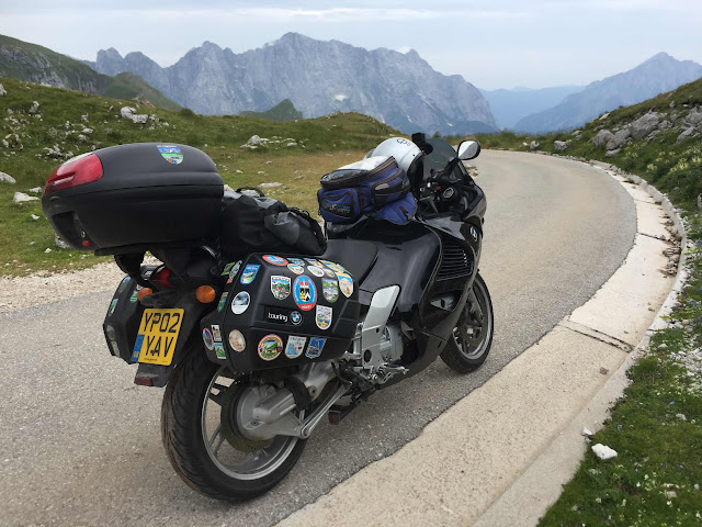
This is the Mangart Road. It doesn’t lead anywhere except to the top of a pass. It costs €5 payable at a little booth a kilometre or so from the turning. It is 11.5km long and rises to a height of 2,072 metres to the Mangart Saddle. It is completely pointless.
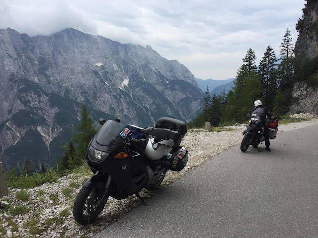
But it is a road no biker should miss out on. Narrow, twisty, unfenced pavement climbs through several tunnels and
balcony sections. There is a one-way loop at the top and if you dismount and walk up the hill for the last 100 metres to the saddle between the high peaks the view is wonderful.
 |
| Coming out of one of the Mangart Road tunnels |
 |
| It’s not for the faint-hearted |
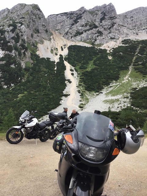
Fortunately for us there is very little traffic up here at the top of the world. Near the summit there is a car park and a half barrier across the road with a sign stating “landslide”. The same sign was there four years ago. Like last time we ignore it and continue up to the top.
 |
| At the car park there is a sign discouraging further travel |
Part way up the final approach there is indeed a slough of rocks across the road. But there is a clear path through for the bike’s wheels. When we get back down Mick remonstrated with the young guy in the booth.
“Why don’t you get up there and clear them rocks? You are charging for 11 kilometres, go and spend a bit on road clearance”
 |
| At the highest paved point |
He has a ready explanation to hand. I guess he has been asked about this many times. There has been a four year dispute between the town who own the road and the park commission who “own” the mountains.
“The problem is with the road”, says the park.
“No it isn’t. It’s the bloody Mountains fault”, says the town.
And so it goes on. It would take a couple of guys with shovels no more than an hour to clear the road completely.
 |
| The view to the north. Austria is in the distance |
 |
| Cold wind’s ablowin’ |
We park up and make the climb up to the top of the saddle. The road was built by the military in 1938 as war loomed over Europe. They marched them up to the top of hill but never finished the descent down the other side. Now it’s a kicking off point for mountaineers and hill walkers and the scene of an annual toboggan race.
 |
| Two lonely bikes |
After a while we make our way back down. There is a strong wind and it is pretty cold up here.
Then it’s back on the bikes for the descent. What a road, what a place. If you are anywhere near, just do it that’s an order !
 |
| Heading down again |
At the bottom of the Mangart we turn back south again retracing our steps back to Bovec and then on down Soca Valley to the little town of Kobarid and Kamp Koren. We have stayed here half a dozen times before and soon have the tents up and a brew going.
It your interested in military history there is an excellent war museum in the centre of the town with many relics from the Great War and a great collection of old photographs.
Another awesome post :) and I've now linked to both the 2017 and the 2018 blogs on my page.
ReplyDelete